
Dehradun in India Map?
Dehradun is a calm, green city with a relaxed pace of life. Hills wrap around the Doon Valley, and the air stays fresh for much of the year. The city keeps a small-town feel, yet it has good schools, cafés, hospitals and shopping. That mix makes it a favourite for students, families and weekend travellers.
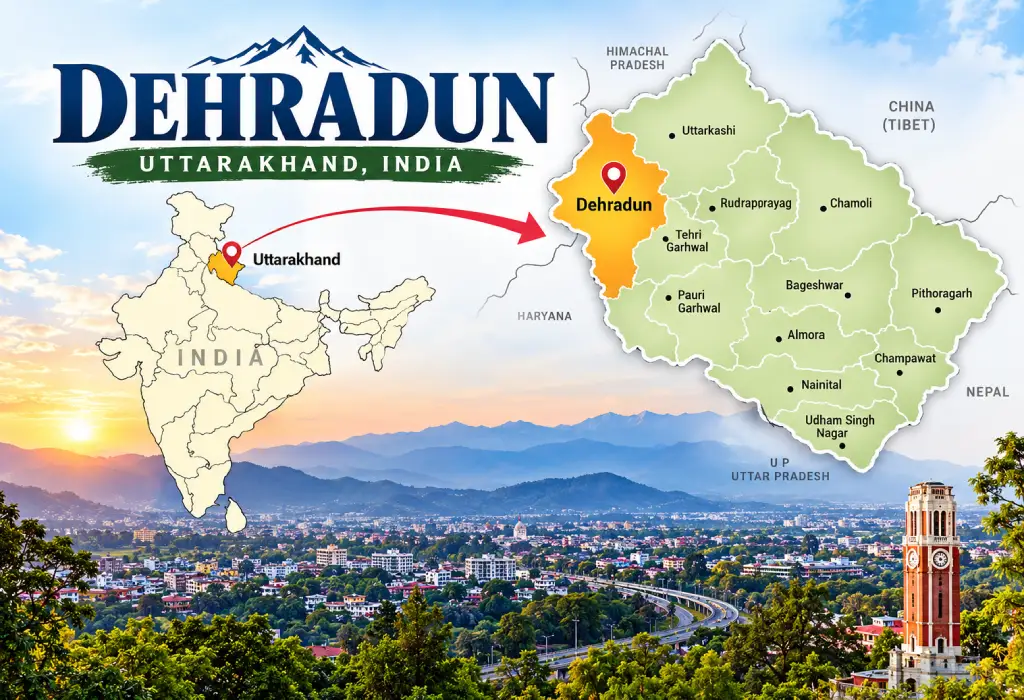
Looking for Dehradun in India map details? You are in the right place. Dehradun is a major city in northern India. It lies in the state of Uttarakhand, at the foot of the Himalayas.
This guide shows you exactly where the city is. You will also learn which districts and states border it, how far it is from big cities and how to reach it.
Dehradun in India Map: Exact Location
Dehradun is in northern India, in the state of Uttarakhand. It sits in the Doon Valley, between the Ganga and Yamuna rivers.
Here are the quick facts:
- State: Uttarakhand
- Division: Garhwal
- Region: Northern India
- Coordinates: About 30.32° N, 78.03° E
- Height above sea level: Around 450 metres
- District area: About 3,088 sq km
- Landscape: A valley with the Shivalik hills on one side and the lower Himalayas on the other
Now look at a map of India. Find Delhi first. Move up and slightly right. You will reach the green hill belt. Dehradun sits there, in the north-west corner of Uttarakhand.
Which State Is Dehradun in India Map?
Dehradun is in Uttarakhand. Uttarakhand is a hill state in northern India. It became a separate state in 2000. Before that, it was part of Uttar Pradesh.
On a political map, you can find the state in three quick steps:
- Locate Delhi in northern India.
- Move north to the Himalayan belt.
- Look for Uttarakhand, which sits between Himachal Pradesh and Nepal.
Dehradun lies in the north-west part of the state. Two other states touch the Dehradun district:
- Himachal Pradesh lies to the west.
- Uttar Pradesh lies to the south.
Is Dehradun the Capital of Uttarakhand?
Yes, but with a twist. Dehradun is the winter capital of Uttarakhand. It has also worked as the state’s interim capital since 2000.
In 2020, the state named Gairsain, in Chamoli district, as its summer capital. So Uttarakhand has two capitals. Even so, Dehradun is the state’s largest city and its main administrative hub.
Dehradun Border Districts Map: Neighbouring Districts and States
The Dehradun district shares borders with four districts in Uttarakhand, one district in Himachal Pradesh and one district in Uttar Pradesh. Here is the full picture:
- North and north-west: Uttarkashi (Uttarakhand)
- East: Tehri Garhwal (Uttarakhand)
- East: Pauri Garhwal (Uttarakhand)
- South (tip): Haridwar (Uttarakhand)
- South and south-west: Saharanpur (Uttar Pradesh)
- West: Sirmaur (Himachal Pradesh)
Rivers shape some of these borders. The Tons and Yamuna rivers separate Dehradun from Sirmaur in Himachal Pradesh. The Ganga also flows through the eastern part of the district on its way to Haridwar.
Keep in mind that these are district borders. They show the area around the whole Dehradun district, not just the city centre. The city itself lies in the middle of the district, in the Doon Valley.
What Is Dehradun Known For?
Dehradun is more than a dot on the map. It is a busy, green and popular city.
People know it for:
- Education: Well-known schools, colleges and institutes
- Defence training: The Indian Military Academy is here
- Research: Several national research centres
- Pleasant weather: Cooler than the plains for much of the year
- Hill access: Mussoorie is a short drive away
Places to Visit Near Dehradun
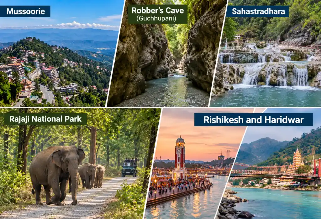
Many travellers use the city as a base. These spots are easy to add to your plan:
- Mussoorie: A hill station with cool air and valley views
- Robber’s Cave (Guchhupani): A natural cave with a stream running through it
- Sahastradhara: Sulphur springs and scenic waterfalls
- Rajaji National Park: A forest reserve for wildlife lovers
- Rishikesh and Haridwar: Famous spiritual towns nearby
How to Find Dehradun in India Map: Nearby Landmarks
Nearby places make the city easy to spot. Here are the approximate road distances:
- Mussoorie: 35 km
- Rishikesh: 45 km
- Haridwar: 55 km
- Chandigarh: 170 km
- Delhi: 210–250 km (depends on route)
Distance From Delhi to Dehradun
The road distance from Delhi to Dehradun is about 210 km on the new expressway and about 250 km on the old route. The expressway takes around 2.5 hours. The old highway often takes 5 to 6 hours.
Delhi–Dehradun Expressway
The Delhi–Dehradun Expressway opened in April 2026. It starts near Akshardham in Delhi. It passes through Uttar Pradesh and ends in Dehradun. It also has a long elevated stretch near Rajaji National Park, which lets wildlife cross safely.
The Old Highway Route
You can still use the older road through Meerut, Muzaffarnagar and Roorkee. It is longer and busier. Use it only if the expressway does not suit your plan.
How to Reach Dehradun
You have three easy options.
By Road
Roads are the most popular choice. Buses and taxis run daily from Delhi, Chandigarh and Haridwar. Driving your own car also works well.
By Train
Dehradun Railway Station links the city to Delhi and other big cities. The Shatabdi Express from Delhi is a favourite for its speed and comfort.
By Air
Jolly Grant Airport is the nearest airport. It lies about 25 km from the city centre. Flights connect Dehradun with Delhi and several other major cities.
Best Time to Visit Dehradun
The weather changes a lot during the year. Pick the season that fits your plans.
- March to June: Warm and pleasant. This is good for sightseeing.
- July to September: Heavy rain. The hills look green, but roads can get slippery.
- October to November: Clear skies and mild days. Many travellers love this season.
- December to February: Cold mornings and nights. Nearby peaks may get snow.
Tips for Reading Dehradun on a Map
Use these simple tips to avoid confusion:
- Start with Delhi and move north
- Look for Haridwar and Rishikesh, which are very close
- Check the Himalayan foothills on a physical map
- Use a district map to see the neighbouring districts
- Use Google Maps or a Survey of India map for the exact view
- Zoom in to see the shape of the Doon Valley
Why the Location Matters
Dehradun is a gateway city. It connects the plains with the Himalayas. Pilgrims pass through on the way to the Char Dham sites. Students come for quality education. Tourists use it as a base for hill trips.
That is why knowing Dehradun in India map details helps with travel, study and trip planning.
Read more about Uttarakhand: Uttarakhand district map, destructive flash floods in Uttarakhand, the Monal, the Himalayan bird, what is the capital of Uttarakhand, how many districts are in Uttarakhand and the Uttarakhand slogan.
Plan Your Dehradun Trip With Confidence
Dehradun is easy to find once you know the clues. It sits in northern India, in Uttarakhand, about 210 to 250 km from Delhi. Himachal Pradesh and Uttar Pradesh lie nearby, and hills and two major rivers frame the valley.
Use the distances, routes and landmarks above to plan your journey. Open a map, trace the route, and enjoy the trip.
Dehradun Satellite Map & Directions
Destination: Dehradun, Uttarakhand
Or enter your starting location manually:
One Response