
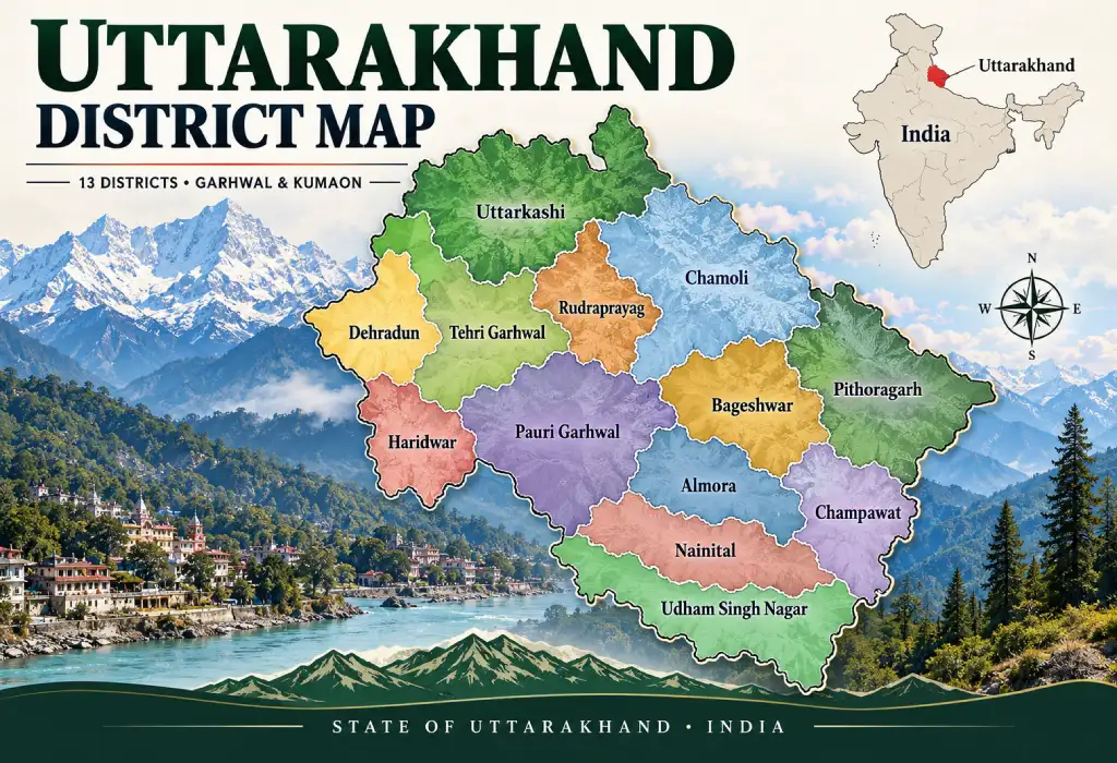
Uttarakhand District Map
Snow-capped peaks, holy rivers, thick forests and busy plains all fit inside one small state. The Uttarakhand district map shows how they fit together, and it is the easiest way to understand this Himalayan state. There are just 13 districts, but each one feels like a different world. This guide makes the map simple. You will see where each district lies, how the state is divided and what makes each district special. You will also learn where Uttarakhand sits on the India map.
Where Is Uttarakhand in India Map?
Uttarakhand lies in northern India, in the Himalayan region. On the India map, look above Uttar Pradesh and below Tibet. It is a hill state, and its position near two international borders makes it important for both travel and security.
Here are its borders:
- North: Tibet (China)
- East: Nepal
- South and south-east: Uttar Pradesh
- West and north-west: Himachal Pradesh
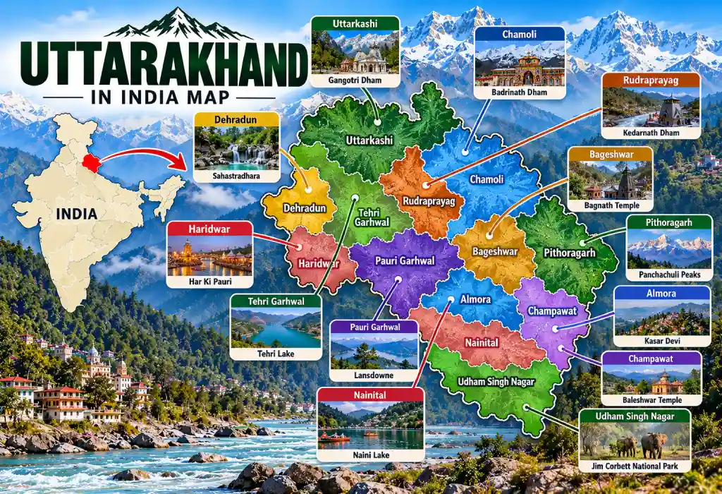
The state covers about 53,483 sq km. It stretches roughly 320 km from north to south and 358 km from east to west. Its latitude runs from about 28°43′ N to 31°27′ N. Around 86% of the land is mountainous. Only about 14% is plains.
Uttarakhand became a state on 9 November 2000. Before that, it was part of Uttar Pradesh. The last census, held in 2011, counted 10,086,292 people here. Census 2027 will update this figure.
Uttarakhand District Map at a Glance
The state has 13 districts. It inherited all 13 from Uttar Pradesh in 2000, and no new district has been officially created since then. Even so, the districts differ a lot in size, height and population. Some sit in the high Himalayas, while others lie in flat farmland near the plains.
Two divisions group these districts:
- Garhwal division (7): Chamoli, Dehradun, Haridwar, Pauri Garhwal, Rudraprayag, Tehri Garhwal and Uttarkashi
- Kumaon division (6): Almora, Bageshwar, Champawat, Nainital, Pithoragarh and Udham Singh Nagar
Dehradun is the temporary (winter) capital. Gairsain, also called Bhararisain, in Chamoli district was declared the summer capital in March 2020.
Complete List of Uttarakhand Districts
The table below gives you every district in one place. It shows each headquarters, the division it belongs to and what the district is best known for.
| District | Headquarters | Division | Known for |
|---|---|---|---|
| Almora | Almora | Kumaon | Old hill town with temples and Kumaoni culture |
| Bageshwar | Bageshwar | Kumaon | Kausani and Himalayan views |
| Chamoli | Gopeshwar | Garhwal | Badrinath, Hemkund Sahib, Valley of Flowers |
| Champawat | Champawat | Kumaon | Smallest district by area |
| Dehradun | Dehradun | Garhwal | Winter capital, Mussoorie, Rishikesh |
| Haridwar | Roshnabad (Haridwar town) | Garhwal | Ganga ghats, most populous district |
| Nainital | Nainital | Kumaon | Naini Lake, state High Court |
| Pauri Garhwal | Pauri | Garhwal | Lansdowne and quiet hill towns |
| Pithoragarh | Pithoragarh | Kumaon | Borders both Tibet and Nepal |
| Rudraprayag | Rudraprayag | Garhwal | Kedarnath, least populous district |
| Tehri Garhwal | Tehri | Garhwal | Tehri Dam |
| Udham Singh Nagar | Rudrapur | Kumaon | Plains, farming and industry |
| Uttarkashi | Uttarkashi | Garhwal | Gangotri and Yamunotri |
How to Read the Uttarakhand District Map
Reading the map is easy if you do not try to take it all in at once. Think of the state as a staircase that climbs from the plains in the south to the glaciers in the north. Split it into three zones and every district finds its place.
- Northern zone: High peaks and glaciers. Uttarkashi, Chamoli and Pithoragarh lie here.
- Middle zone: Hills, rivers and small towns. Tehri, Pauri, Rudraprayag, Almora and Bageshwar sit here.
- Southern zone: Plains and foothills. Haridwar, Udham Singh Nagar and the lower parts of Dehradun and Nainital fall here.
Rivers also help. The Ganga begins at Gangotri and the Yamuna at Yamunotri, both in Uttarkashi. The Bhagirathi, Alaknanda and Mandakini run through Garhwal. The Kali River marks much of the border with Nepal.
Steep slopes and heavy monsoon rain also make parts of these hill districts prone to sudden floods. You can read more in our article on destructive flash floods in Uttarakhand.
How the 13 Districts Were Formed
The map did not always look like this. Most of today’s districts were carved out of older ones while the area was still part of Uttar Pradesh. In 1960, Uttarkashi, Chamoli and Pithoragarh were created, mainly to run the border areas better. Haridwar followed in 1988, and Udham Singh Nagar in 1995. In 1997, three more districts arrived: Bageshwar, Champawat and Rudraprayag. After the state formed in 2000, the count stayed at 13.
Garhwal Districts on the Uttarakhand District Map
Garhwal lies in the western part of the state. It is the land of the great river sources and the biggest pilgrimage sites. Its seven districts run from the busy plains of Haridwar to the snowy border of Uttarkashi and Chamoli.
- Dehradun: The capital district. Mussoorie, Rishikesh, Landour and Chakrata all fall in it.
- Haridwar: The most populous district. The Ganga enters the plains here.
- Pauri Garhwal: A hill district. Lansdowne is its best-known hill town.
- Tehri Garhwal: Home to the Tehri Dam. At 260.5 m, it is the tallest dam in India.
- Rudraprayag: It has Kedarnath. It also has the highest share of forest cover in the state.
- Chamoli: The largest district by area, at about 8,030 sq km. It holds Badrinath, Hemkund Sahib and the Valley of Flowers.
- Uttarkashi: The source of both the Ganga and Yamuna. It has the lowest population density, about 41 people per sq km.
Kumaon Districts on the Uttarakhand District Map
Kumaon lies in the eastern part of the state. It is known for its lakes, hill towns and Kumaoni culture. Its six districts stretch from the Terai plains near Uttar Pradesh up to the Tibet and Nepal borders.
- Nainital: A lake town and the seat of the state High Court. Corbett National Park is also linked to this district.
- Almora: A cultural hill town with old temples and Kumaoni traditions.
- Bageshwar: A small district. Kausani offers wide views of the Himalayas.
- Champawat: The smallest district, at about 1,781 sq km. It touches the Nepal border.
- Pithoragarh: A large border district beside both Tibet and Nepal.
- Udham Singh Nagar: A plains district. Rudrapur is its headquarters, and farming and industry drive its economy.
Border Districts on the Map
Uttarakhand sits on two international borders, so some districts have a special role. Five districts touch a border. Uttarakhand shares about 350 km with China and about 275 km with Nepal. The state government and the army pay close attention to these areas.
- Tibet (China): Uttarkashi, Chamoli and Pithoragarh
- Nepal: Pithoragarh, Champawat and Udham Singh Nagar
Pithoragarh is the only district that touches both countries.
Key Facts From the Uttarakhand District Map
The map hides a few facts that surprise many readers. Some districts are huge but almost empty, while others are small and crowded. These quick points help students and travellers see the pattern:
- Largest district by area: Chamoli
- Smallest district by area: Champawat
- Most populous district: Haridwar (1,890,422 people in 2011)
- Least populous district: Rudraprayag
- Most densely populated: Haridwar, with about 800 people per sq km
- Highest peak: Nanda Devi, about 7,816 m, in Chamoli district
- Biggest glacier: Gangotri, in Uttarkashi
Four districts hold most of the people. Dehradun, Haridwar, Udham Singh Nagar and Nainital together house over 60% of the state. That is why the plains look busy while the high hills stay quiet.
Census 2027 and Uttarakhand’s Population
All population figures in this guide come from Census 2011, the last full census. India is now preparing for Census 2027, the first population count since then. It runs in two phases: house-listing first, then population enumeration. New district-wise numbers will come once the count is complete, so some rankings may change.
Uttarakhand has its own schedule because of its snow-bound areas:
- Snow-bound areas of Uttarakhand: Enumeration in September 2026, with a reference date of 1 October 2026
- Rest of Uttarakhand: Enumeration from 1 December 2026 to 4 January 2027, with a reference date of 5 January 2027
- Self-enumeration (rest of the state): 16 to 30 November 2026
Dates can change, so check the official Census of India website for the latest update.
National Parks and the District Map
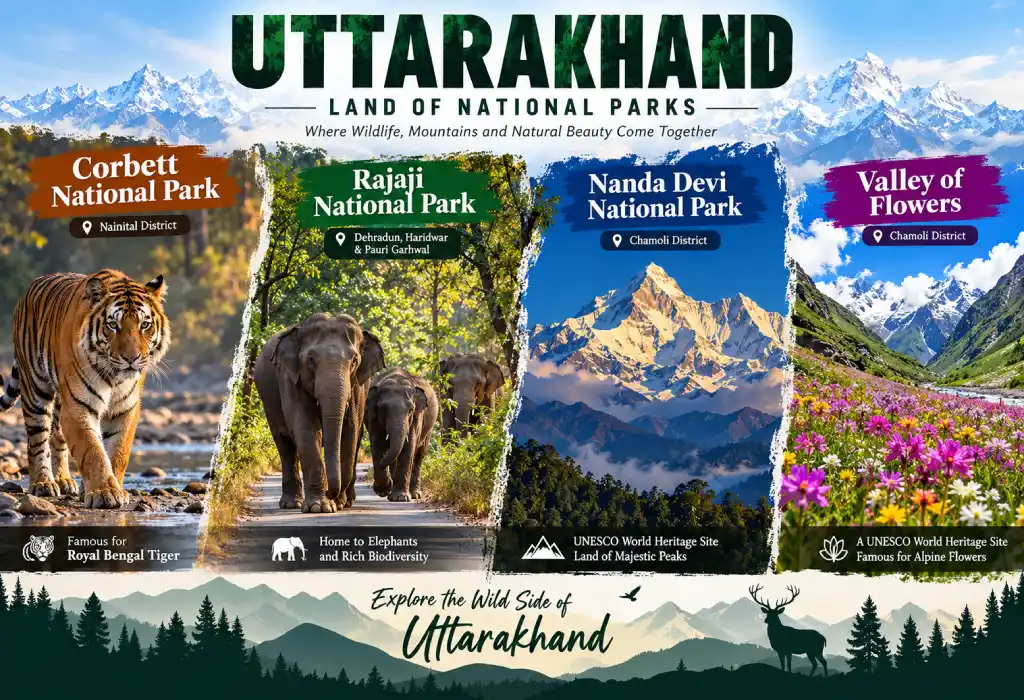
Uttarakhand is a top destination for wildlife lovers. Forests cover large parts of the state, and several national parks stretch across more than one district. Wildlife fans can match parks to districts:
- Corbett National Park: Spread across Nainital and Pauri Garhwal. Ramnagar is the base town.
- Rajaji National Park: Covers parts of Haridwar, Dehradun and Pauri Garhwal.
- Nanda Devi National Park: Lies in Chamoli.
- Valley of Flowers: Also in Chamoli.
The state also has its own state bird. The colourful Himalayan monal lives in high-altitude forests and meadows. To learn more, read our guide to the monal Himalayan bird.
Char Dham and the District Map
Many visitors search for the Uttarakhand district map to plan the Char Dham Yatra. The route covers four holy shrines in the high Himalayas, and the pilgrimage depends on good planning. Knowing which district each shrine lies in helps you choose your route, stay and travel time. The four shrines lie in three districts:
Will Uttarakhand Get New Districts?
The idea has come up many times. In 2011, the government announced four new districts: Yamunotri, Kotdwar, Ranikhet and Didihat. In 2016, the plan grew to nine. It added Rishikesh, Roorkee, Ramnagar, Kashipur and Sitarganj-Khatima. In August 2022, the Chief Minister again said the process would start soon.
So far, none of these districts has been formally notified. The state still has 13. Local leaders say smaller districts would help remote hill areas. Always check official government sources for updates.
Why the Uttarakhand District Map Matters
A good map does more than show lines. It turns a long list of names into a picture you can remember. Whether you study for an exam, plan a trip or research the region, the map saves time and avoids confusion.
- Students: Learn names, headquarters and divisions for exams.
- Travellers: Plan routes between hills and plains.
- Researchers: Compare population, area and density.
- Locals: Understand how the state is run.
Know Uttarakhand, One District at a Time
The Uttarakhand district map shows a state of two halves. Garhwal has seven districts and Kumaon has six. Each one adds its own mountains, rivers, culture and history. Start with the table above, then trace each district on the map. Within minutes, the whole state will make sense.
2 Responses